| Nisargadhama |
| Nisargadhama |
| Talasseri Railway Station |
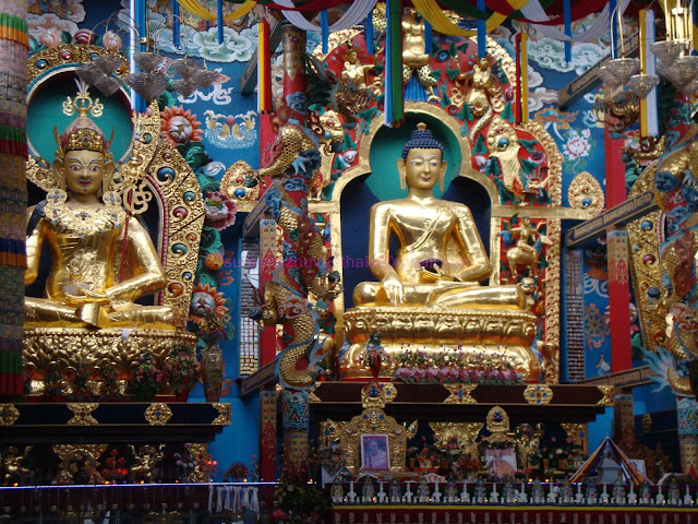
2011August 28 & 29 was the two days ,we visited Coorg.it was raining and raining.Purushothaman,Muthu,Manikandan and Me started the journey from Pattambi.we caught a train to Thalasseri,then line Bus to Virajpet through Iritty.Night Stay was at Kusalnagar.Early morning we visited Bailakuppe .Bylakuppe is home to two of the many Tibetian settlements in India, established by Lugsum Samdupling (in 1961) and Dickyi Larsoe (in 1969). It is located to the west of the Mysore district in Karnataka. The twin town Kushalanagara is about 6 km from Bylakuppe.Bylakuppe has a police station, commercial banks, a telephone exchange, a post office, lodges and hotels. Transport facilities such as buses, auto-rickshaws and taxis are also available.Namrodoling Monastery (Golden Temple), Other monasteries, schools ,farms and settlements are attractive..
After a Chinese breakfast we went to Nisargadhama ,3Km from Kusalnagar.Nisargadhama is an island ( 64-acre (260,000 m2) island formed by river Kaveri ,with lush foliage of thick bamboo groves, sandalwood and teak trees and surrounded by the Kaveri river. The island is accessible through a hanging rope bridge. There are deer, rabbits, peacocks, and a children's playground and orchidarium. Having a line bus we reached Madikkeri around 12:30PM.Madikker(Mercara), is the headquarters of Kodagu ( Coorg) district.Madikeri was formerly known as Muddu raja keri. Muddurajakeri which means Mudduraja's town, was named after the prominent Haleri king, Mudduraja who ruled Kodagu from 1633-1687..then we saw the following places......
Raja's sit This is a small square mantapa in brick and mortar of four pillars bridged by arches, enhanced by beautiful surroundings. This spot was a favourite place of recreation for the Rajas and hence was permanently associated with them. It is built on a high level ground with a commanding view of the cliffs and valleys to the west.
Madikeri Fort: This fort was first built by Mudduraja in the last quarter of the 17th century. He also built a palace inside the fort. It was eventually rebuilt in granite by Tipu Sultan who named the site as Jaffarabad. In 1790, Doddavira Rajendra took control of the fort. The British who added to the fort in 1834. The palace was renovated by Lingarajendra Wodeyar II in 1812-1814. In the north-east corner at the entrance are two life size masonry elephants and a church is present in the south-east corner. There is a famous Lord Ganesha temple known as "Kote ganapathi" just at the main entrance of the fort.
Omkareshwara Temple: Located at the heart of the Town,Omkareshwara temple was built by king Lingarajendra in 1820. The temple has both Islamic and Gothic styles of architecture, built around a central pool. It is said Lingarajendra killed an honest and pious Brahmin to fulfill his political ambitions. That Brahmin became a "Brahmarakshasa" and started troubling the king. In order to purify himself for the killing of a Brahmin, he was advised to construct a temple to Lord Shiva. He brought a Shivalinga from Kashi, and the temple was built and named "Omkareshwara".
The next spot is Bhagamandala.After a 45 minuts travel (33Kms from Madikkeri) in the bus we reached there.The climate was worse.Heavy rain and cold. Bhagamandala is a pilgrimage place in Kodagu district . It is situated on the river Kaveri in its upstream stretches. At this place, the Kaveri is joined by two tributaries, the Kannike and the mythical Sujyoti river. It is considered sacred as a river confluence.Near this Thriveni sangamam ,Sri Bhagandeshwara temple, where Bhagandeshwara (Ishwara), Subramanya, Mahavishnu and Ganapati idols are installed. This place is also known as Bhagandeshwara Kshetra, from which the name Bhagamandala is derived. The temples in this area are built in Karavali(West Coast) style. We visited there .The Priest was Purushothaman's neighbour.During 1785–1790, the area was occupied by Tipu Sultan. He renamed Bhagamandala to Afesalabad. In 1790 King Dodda Vira Rajendra took Bhagamandala back into an independent Kodagu kingdom.
Next we took an Auto to Thalakkaveri (8Km) .Talakaveri is the place that is generally considered to be the source of the river Kaveri. It is located by Brahmagiri hill (not to be confused with the Brahmagiri range further south) 1,276 m. above sea level. A tank or kundike has been erected on a hillside, at the place that is said to be the origin.Mist ,rain and wind totally wet us.Then we get a bus to Virajpet. We never forget that rainy wet night.The kodagu policemen expelled us from the bus station.We stand there untill got a rush bus at 2:00AM.Around 5:00AM we get Thalasseri again.
.jpg) |
| Omkareswara Temple |
.jpg)
.jpg)
.jpg)
.jpg)
.jpg)
.jpg)
.jpg)
.jpg)
.jpg)
.jpg)
.jpg)
.jpg)
.jpg)
.jpg)
.jpg)
.jpg)
.jpg)
.jpg)
.jpg)
.jpg)
.jpg)
.jpg)
.jpg)
.jpg)
.jpg)
+copy.jpg)
+copy.jpg)
+copy.jpg)
+copy.jpg)
.jpg)